El Niño 2026 Has Arrived: What a Potentially Historic Event Means for Global Weather
By NatureWeatherHub Team
Reading Time: 6 Minutes
In the central Pacific Ocean, a vast reservoir of warm water is rising toward the surface. It is not a local event. It is a signal that global weather is about to shift, and no continent is entirely out of its reach.
Last Thursday, the National Oceanic and Atmospheric Administration confirmed what ocean buoys and satellite readings had been hinting at for weeks: El Niño has officially developed in the tropical Pacific. Sea-surface temperatures in the central and eastern equatorial Pacific have crossed the 0.5 degrees Celsius above-average threshold for several consecutive months, the formal marker of an El Niño event. The World Meteorological Organization now puts the probability of El Niño conditions persisting through November 2026 at nearly 90 percent, with an 80 percent likelihood as early as the June through August window.
This is not a routine climate fluctuation. Forecast models suggest this event could strengthen to moderate or even strong levels by autumn. The European Commission’s Joint Research Centre has described it as a “potentially historic El Niño.” NOAA puts the odds of a “very strong” event, with an anomaly exceeding 2 degrees Celsius, at 63 percent.
What Happened Beneath the Surface
The clearest sign that this El Niño carries unusual force is hidden underwater. Subsurface temperatures across the tropical Pacific are already more than 6 degrees Celsius above average, according to the WMO. That is a massive store of heat, waiting to be released into the atmosphere over the months ahead.
The Southern Oscillation Index, which tracks the atmospheric pressure difference between Tahiti and Darwin, Australia, has also shifted into El Niño territory. When the ocean and the atmosphere move together like this, the signal becomes harder to ignore.
The United Nations Secretary-General, António Guterres, addressed the moment directly in early June. “The science is clear: El Niño is arriving on our doorstep in the coming months with 90 percent certainty,” he said. “The world must treat it as the urgent climate warning it is. El Niño conditions will pour fuel on the fire of a warming world.”
Why El Niño Happens
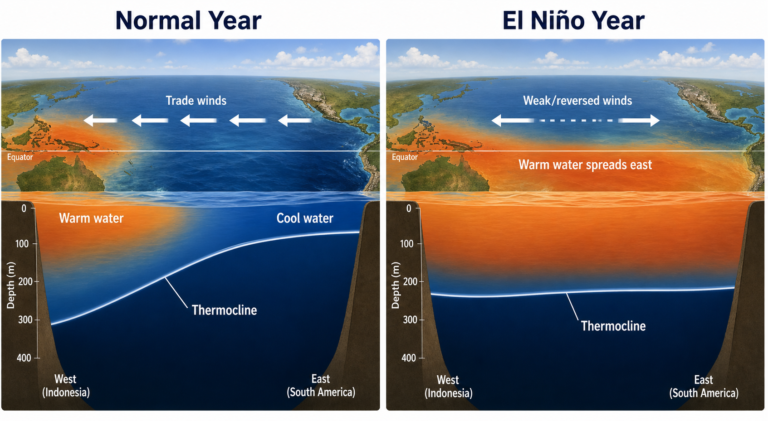
El Niño is the warm phase of the El Niño-Southern Oscillation, or ENSO, a natural climate cycle that has shaped global weather for thousands of years. Under normal conditions, trade winds blow westward across the tropical Pacific, pushing warm surface water toward Indonesia and allowing cooler, nutrient-rich water to rise near South America.
During an El Niño event, those trade winds weaken or even reverse. The pool of warm water that normally sits in the western Pacific sloshes back eastward, spreading across the central and eastern ocean. That shift releases enormous amounts of heat and moisture into the atmosphere, disrupting circulation patterns that steer rainfall, storms, and temperature across much of the planet.
El Niño events typically develop between March and June, peak between November and February, and last nine to twelve months. They occur every two to seven years. The most recent event, in 2023-24, was one of the five strongest on record and played a measurable role in pushing 2024 to become the hottest year ever recorded.
Climate change does not appear to be increasing the frequency or intensity of El Niño events themselves. But it is amplifying their effects. A warmer baseline atmosphere means the heat and rainfall disruptions caused by El Niño now land on a planet already running a fever.
Social Media Highlight
“El Niño is not just an ocean pattern. It is a global chain reaction that can turn dry regions to dust, wet regions to flood zones, and ordinary heat into a health emergency.”
How It Affects People
The human consequences of a strong El Niño ripple outward through food systems, water supplies, economies, and public health.
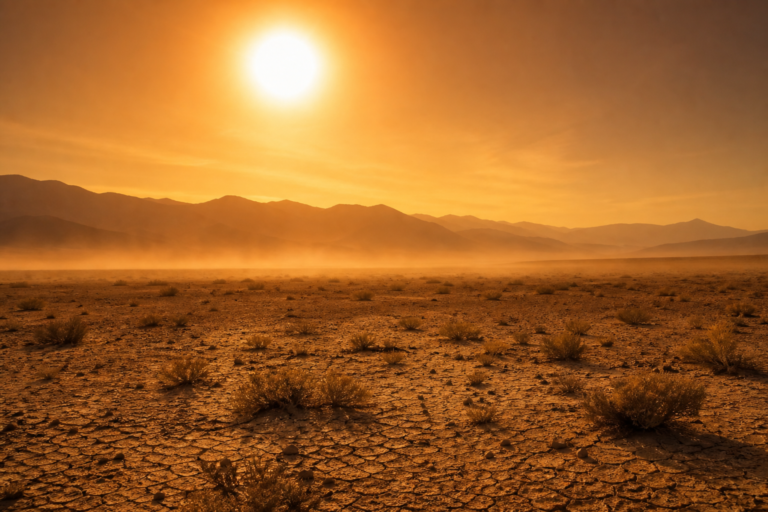
Food. Crop failures become more likely across several major agricultural regions during El Niño. Australia, sub-Saharan Africa, and Southeast Asia face elevated drought risk, threatening wheat, maize, and rice production. The South Asian Climate Outlook Forum has already forecast a below-average monsoon for the region, which could reduce harvests for hundreds of millions of small-scale farmers. Fisheries also suffer: when warm water suppresses the upwelling of nutrients off the coast of South America, fish populations decline, affecting livelihoods from Peru to Ecuador.
Water. The pattern is painfully uneven. While some regions dry out, others are inundated. Parts of the southern United States, the Horn of Africa, and central Asia face a higher likelihood of heavy rainfall and flooding. In the Greater Horn of Africa, forecasters see a high probability of below-normal rainfall during the critical June-through-September rainy season, a blow for communities still recovering from years of drought. Central America is expected to face drier and warmer conditions, adding pressure to water resources already stretched thin.
Economy. The 2023-24 El Niño contributed to an estimated $100 billion in global economic losses, and a stronger event in 2026 could push that figure higher. Agricultural losses ripple into food prices. Insurance claims rise. Governments face the strain of simultaneous emergencies, from wildfire response to flood relief.
Health. Heatwaves become longer and more intense during El Niño years, and the health toll is rarely confined to one region. WMO Secretary-General Celeste Saulo warned that this event “will exacerbate drought and heavy rainfall and increase the risk of heatwaves both on land and in the ocean.”
Travel. Extreme weather disrupts transport networks. Flooded roads, cancelled flights, and dangerous heat conditions at outdoor events become more common. For those traveling to regions affected by drought or fire, the risks are not always obvious until they arrive.
Why It Matters Now
The world is hotter now than it was during the last major El Niño. The baseline has shifted upward, and that changes the stakes. Global temperatures during El Niño events tend to be most extreme in the second year after onset. If this El Niño strengthens into a historic event, 2026 or 2027 could set new global temperature records, building on the record set in 2024.
There is one counterintuitive piece of relatively positive news: El Niño tends to suppress Atlantic hurricane formation by increasing wind shear that tears apart developing storms. NOAA has forecast a 55 percent chance of a below-normal Atlantic hurricane season in 2026. But the agency’s experts add a familiar warning: it only takes one storm making landfall to create a disaster.
Meanwhile, the Pacific hurricane season often becomes more active during El Niño, shifting the geography of storm risk rather than eliminating it.
What We Can Learn
The single most important lesson from past El Niño events is that early warning saves lives. Scientists have been tracking this one since its earliest signals appeared in ocean temperature data months ago. The WMO, NOAA, and national weather agencies around the world have given governments and communities time to prepare.
That preparation can take concrete forms. In drought-prone regions, water conservation, drought-resistant crops, and early livestock management make a measurable difference. In flood-risk zones, clearing drainage systems, reinforcing infrastructure, and having evacuation plans ready reduce casualties and damage. For heatwaves, cooling centers, public health alerts, and simple precautions stay hydrated, avoid peak sun, check on elderly neighbors remain the most effective responses.
The 2023-24 El Niño also taught a harder lesson: the impacts are not evenly distributed. Lower-income countries and communities with fewer resources bear a heavier share of the damage, even though they contribute least to the carbon emissions that are warming the baseline. Preparing for El Niño is not just a scientific challenge. It is a question of global fairness.
A strong El Niño in 2026 will test the early warning systems, disaster preparedness plans, and adaptation strategies that have been put in place over the past decade. The test is not whether the event arrives. It is whether the world is ready when it does.
Final Call to Action
“The ocean is telling us something. The question is whether we are listening closely enough to act before the damage is done.”
Every El Niño is different, but the pattern is familiar. Warm water spreads across the Pacific. Trade winds falter. Weather systems thousands of miles away reorganize themselves in response. What makes this one different is the heat already stored in the ocean, the speed at which conditions have developed, and the fact that it is unfolding on a planet that has not stopped warming. The warnings are clear. The preparation window is now.