What Is a Derecho? The Inland Storm Stronger Than a Hurricane
On June 10, 2026, a wall of wind spanning 350 miles tore across Iowa, Illinois, Wisconsin, and Indiana. It snapped power poles, flipped semi-trucks, and cut electricity to half a million households. The storm was a derecho.
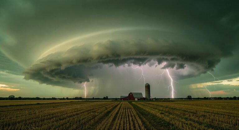
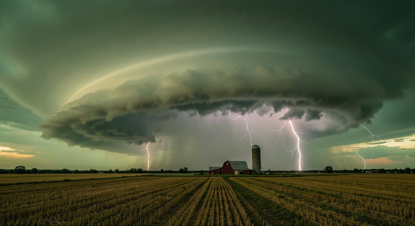
A derecho (pronounced deh-REY-cho) is a widespread, long-lived straight-line windstorm driven by a fast-moving line of thunderstorms. NOAA’s definition requires a damage swath of at least 250 miles, gusts of 58 mph along most of that path, and several well-separated gusts above 75 mph. The word is Spanish for “straight ahead,” coined in 1888 to separate these winds from the twisting destruction of a tornado.
A derecho is not an inland hurricane, despite the common comparison. Hurricanes are born over warm ocean water and weaken over land (see our hurricane explainer). Derechos form over land from ordinary thunderstorms that organize into something more violent.
How a Line of Thunderstorms Becomes a Derecho
Derechos are built by downbursts: columns of rain-cooled air that plummet from a thunderstorm and slam into the ground at speeds exceeding 100 mph. A single downburst spans four to six miles. When dozens fire in sequence along a storm line, they merge into a cluster stretching 60 miles or more.
The process feeds itself. Rain-cooled air hits the ground and races ahead as a gust front, a miniature cold front that lifts warm, humid air and spawns new storms. Those storms produce more rain, cool more air, and accelerate the front. On radar, the line bows outward. Meteorologists call this a bow echo, the signature of a derecho unfolding.
A rear-inflow jet tilts the updraft backward, feeding more energy into the system. With strong winds aloft and ample surface instability, the bow echo sustains itself for hundreds of miles and several hours.
Two types emerge. Progressive derechos form in warm months, May through August, as a single bow line racing across the Northern Plains and Upper Midwest. Serial derechos appear in cooler months as multiple bow echoes embedded in a squall line stretching from Texas toward the Southeast.
When 90-Mile-an-Hour Wind Hits a Neighborhood
About half of all recorded derecho fatalities occur in vehicles or boats. High-profile vehicles blow over easily. Boaters face hurricane-force gusts that can capsize a vessel in seconds.
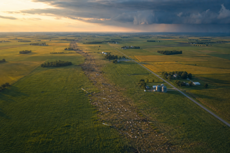
For homeowners, damage is indiscriminate. Straight-line winds topple trees onto roofs, tear away siding, and shatter windows. Power outages last days. After the June 2026 derecho, more than 300,000 customers remained dark into the next afternoon. Urban neighborhoods with overhead lines and large shade trees face the longest recoveries.
The financial toll is enormous. The August 2020 Midwest derecho caused $11 billion in damage. Farmers bear a heavy share: crops flattened across entire counties, grain bins crumpled, irrigation rigs destroyed. In 2025, 91 percent of billion-dollar U.S. weather disasters were severe storm events.
Travel and Infrastructure
Derechos move at 50 to 70 mph. A storm west of you at 3 p.m. can arrive before dinner. Airports suspend operations. Highways clog with fallen trees and downed lines. Rail corridors shut for days of debris clearance.
Why Derechos Demand Attention in 2026
Peak derecho season runs May through August; those four months deliver nearly 70 percent of all U.S. events. The central Plains and Midwest see the highest concentration, but as Tornado Alley shifts east into the South and Ohio Valley, communities unaccustomed to violent straight-line winds are increasingly in the path.
A warmer atmosphere holds more moisture, powering stronger thunderstorm updrafts. Heavier rain, faster evaporative cooling, and stronger downbursts follow. (For background on weather and climate connections, see our weather vs. climate guide.) Straight-line wind speeds in the central U.S. have intensified roughly 7 percent per degree Fahrenheit of warming since 1980. Scientists project derechos will grow more frequent, more widespread, and more intense.
The June 2026 event was not an anomaly. It arrived less than a year after the June 2025 outbreak that carved through North Dakota, Minnesota, and Ontario, producing the first EF5 tornado in the U.S. since 2013. The gap between memorable and catastrophic is narrowing.
What to Do When a Derecho Warning Arrives
There is no separate “derecho warning.” The National Weather Service issues Severe Thunderstorm Warnings, often tagged “destructive” when 80-mph winds are expected. If one arrives, move to the lowest floor of a sturdy building, stay away from windows, and put as many walls between you and the outdoors as possible.
The most dangerous place during a derecho is inside a vehicle or on a boat. If driving when a warning is issued, pull over at the nearest substantial building and take shelter. Do not try to outrun it. A tree-lined highway becomes a hazard zone when 80-mph gusts strike.
At home, secure outdoor furniture before severe weather season. Trim dead branches near your roofline. Keep a battery-powered weather radio charged. A few days of preparation can make a week without power manageable rather than dangerous.
Understanding the difference between a derecho and a tornado matters. Both demand immediate shelter, but the scale differs. A tornado warning covers a county for 30 minutes. A derecho can span several states and last for hours. Take it seriously before the wind begins to howl.
“A derecho is not a tornado and it is not an inland hurricane. It is its own phenomenon: a straight-line wind machine that can stretch across entire states.”
“When a Severe Thunderstorm Warning is tagged ‘destructive,’ treat it like a tornado warning. Get low, get inside, and get away from windows.”