How to Read Clouds: Types & What They Predict
1|—
2|title: “How to Read Clouds: Types & What They Predict”
3|meta_description: “Learn the 10 main cloud types and what each one predicts about incoming weather. Master high, mid, low, and vertical clouds with simple visual cues and memory tricks.”
4|slug: “cloud-types-weather-predictions”
5|—
6|
7|# How to Read Clouds: Types & What They Predict
8|
9|Your weather app says “partly cloudy” — but the sky outside tells a much richer story. A single glance at the clouds can give you a 12-to-36-hour weather forecast that costs nothing and never needs a signal.
10|
11|Clouds follow patterns. Learn those patterns and you learn to read the sky.
12|
13|## The Four Building Blocks
14|
15|Back in 1803, an English pharmacist named Luke Howard stood up at a London science club and proposed a naming system for clouds. His idea was dead simple: every cloud boils down to four Latin roots.
16|
17|- Cirrus — “curl of hair.” Wispy, feathery streaks.
18|- Cumulus — “heap or pile.” Puffy, piled-up cotton balls.
19|- Stratus — “layer.” Flat, even blanket.
20|- Nimbus — “rain.” Dark, wet, and ready to soak you.
21|
22|Mix and match those four words and you get the 10 main cloud types we use today. *Cumulonimbus* literally means “heaped rain cloud.” The name tells you what it does.
23|
24|## High Clouds: The Early Warning System
25|
26|High clouds float between 16,500 and 45,000 feet. They’re made of ice crystals, not water droplets — even in July.
27|
28|### Cirrus — The 24-Hour Heads-Up
29|
30|Thin, white streaks painted across blue sky. Sailors called them “mares’ tails” for good reason — they look like horsehair brushing the stratosphere. Cirrus clouds signal fair weather *right now*, but they’re often the first sign of an approaching warm front. When you see cirrus thickening and lowering over the course of a day, rain or snow usually arrives within 24 to 36 hours.
31|
32|Think of cirrus as the guest who texts “on my way” — the weather change isn’t here yet, but it’s coming.
33|
34|### Cirrostratus — The Halo Maker
35|
36|A thin, milky sheet that spreads across the entire sky. Cirrostratus is subtle — you might miss it entirely until you notice a halo around the sun or moon. That halo is ice crystals bending light. Precipitation typically follows within 12 to 24 hours.
37|
38|### Cirrocumulus — The “Mackerel Sky”
39|
40|Tiny rippled patches that resemble fish scales. An old sailor’s rhyme goes: *”Mackerel scales and mares’ tails make lofty ships carry low sails.”* Usually fair but cold, these clouds rarely bring trouble on their own.
41|
42|## Mid Clouds: The Middle Managers
43|
44|Between 6,500 and 23,000 feet, mid-level clouds mix water droplets and ice crystals. They bridge the gap between fair-weather highs and rain-making lows.
45|
46|### Altocumulus — The Texture Cloud
47|
48|Gray or white patches arranged in rolls or waves. A few altocumulus dots on a warm morning often mean afternoon thunderstorms, especially in humid air. When they spread into a widespread layer — another “mackerel sky” — the atmosphere is getting unstable.
49|
50|### Altostratus — The Dimmer Switch
51|
52|A gray or blue-gray sheet that covers the sky and dims the sun to a flat disk — like looking at it through frosted glass. Shadows disappear. Steady rain or snow usually starts within a few hours. Altostratus knows you had outdoor plans and doesn’t care.
53|
54|### Nimbostratus — The All-Day Soaker
55|
56|Thick, dark, shapeless. This is the cloud that delivers the miserable, steady rain that lasts from breakfast to dinner. No thunder, no drama — just relentless gray and wet pavement. Nimbostratus sits low enough to blot out landmarks and sags under the weight of continuous precipitation.
57|
58|## Low Clouds: Ground-Level Gloom
59|
60|Low clouds hug the sky below 6,500 feet. They’re mostly water droplets and they dominate overcast days.
61|
62|### Stratus — The Gray Blanket
63|
64|Uniform, featureless gray hugging the horizon. Stratus looks like fog that couldn’t be bothered to touch the ground. It produces drizzle, mist, or light snow — nothing dramatic, just the kind of day where everything feels damp and quiet.
65|
66|### Stratocumulus — The Lumpy Blanket
67|
68|A rolling, lumpy layer with patches of darker gray. Unlike stratus, stratocumulus has texture — think of rumpled bed sheets. It rarely produces more than a sprinkle of drizzle and often breaks up by afternoon.
69|
70|### Cumulus — The Fair-Weather Friend
71|
72|Detached puffy clouds with flat bottoms and cauliflower tops. Scattered cumulus on a blue-sky day is what most people mean by “nice weather.” They form when warm air rises in bubbles — as long as they stay small and white, you’re in the clear. When they start stacking vertically, pay attention.
73|
74|## Vertical Clouds: When the Sky Means Business
75|
76|Some clouds don’t stay in their lane. Vertical clouds punch through all three altitude levels, from near the surface up to 60,000 feet.
77|
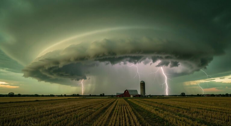
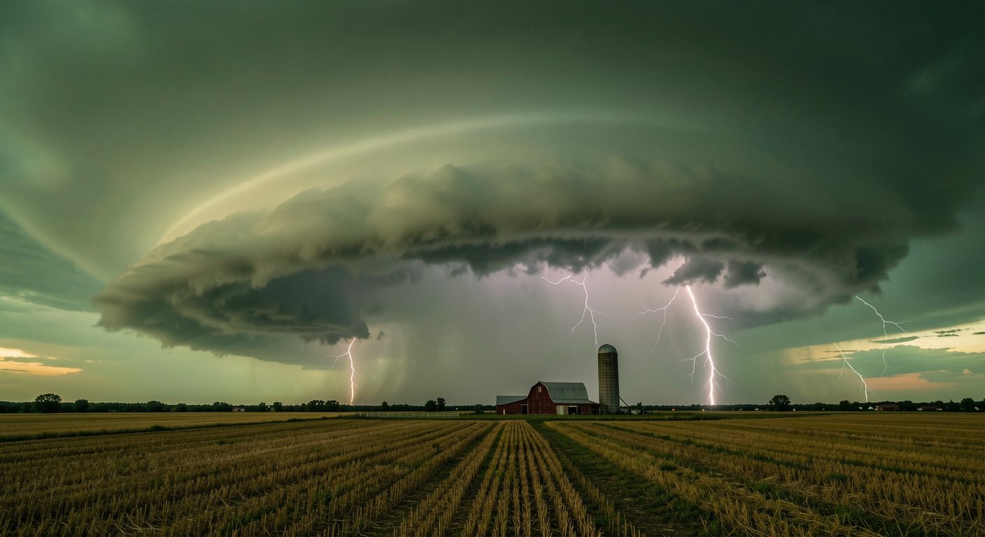
78|### Cumulonimbus — The Thunderhead
79|
80|This is the heavyweight champion. A towering mountain of cloud with a distinctive flat anvil top where it slams into the stable tropopause and spreads sideways. Cumulonimbus is the only cloud type that produces lightning.
81|
82|A single mature cumulonimbus holds over 500,000 tons of water — enough to fill about 125 Olympic swimming pools. It delivers thunderstorms, torrential rain, large hail, and sometimes tornadoes. When you see one building on the horizon, the anvil top points in the direction the storm is moving.
83|
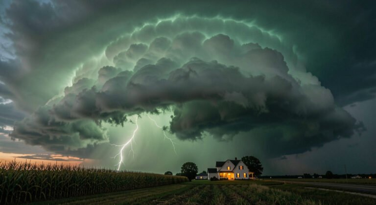
84|### Cumulus Congestus — The Warning Shot
85|
86|Tall, sharp-edged cumulus that looks like a head of cauliflower stretching upward. It hasn’t reached thunderstorm status yet, but a congestus cloud on a hot humid afternoon is a cumulonimbus in training. If the top stays sharp and crisp rather than softening into wispy ice, the atmosphere may still stabilize. If it keeps climbing, find shelter.
87|
88|## Simple Memory Tricks
89|
90|The height rule: The higher the cloud, the nicer the weather. High cirrus means fair now. Low, thick nimbostratus means rain now.
91|
92|The kitchen-table analogy: Cumulus is a pile of mashed potatoes. Stratus is a gray bedsheet pulled across the sky. Cirrus is a dry paintbrush dragged through white paint. Nimbus is that same bedsheet after you dropped it in a puddle.
93|
94|The sailor’s rhyme: *”Mares’ tails and mackerel scales make lofty ships carry low sails.”* When you see cirrus streaks and rippled altocumulus together, a storm is approaching. Shorten sail — or grab an umbrella.
95|
96|## What This Means for You
97|
98|Next time you step outside, look up before you look at your phone. Cirrus streaks thickening in the west tell you to pack a rain jacket tomorrow. Towering cumulus on a humid afternoon says to move the picnic indoors. The sky is a free weather station — you just need to learn its language.
99|
100|—
101|
102|*NatureWeatherHub publishes clear, practical weather explainers for everyday readers. Share this guide with anyone who likes knowing what’s coming before the app does.*
103|