The 2026 Atlantic Hurricane Season: Why Early Signs Point to Above-Normal Activity
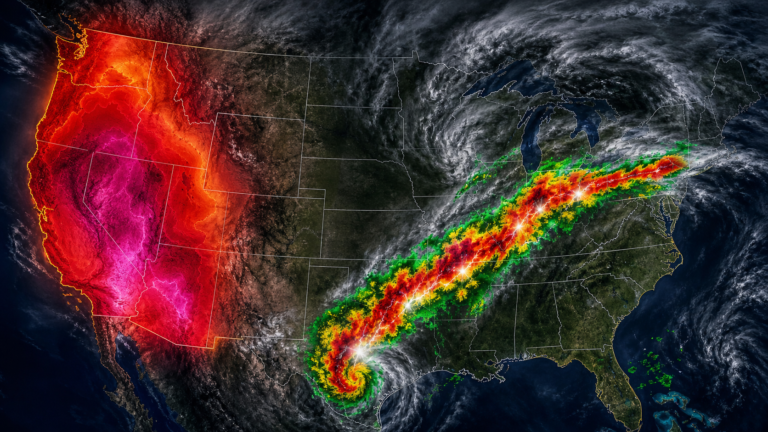
Tropical Storm Arthur made landfall near Galveston, Texas, on June 17, 2026, with winds of just 45 mph. The storm caused more than $100 million in damage and claimed four lives. [SOURCE: https://en.wikipedia.org/wiki/2026_Atlantic_hurricane_season]
It also surfaced a question forecasters have been wrestling with for months: is the Atlantic heading toward a quiet hurricane season, or are the ocean’s signals telling a different story?
What Is Happening
NOAA’s May 21 outlook calls for 8 to 14 named storms, 3 to 6 hurricanes, and 1 to 3 major hurricanes. The agency assigns a 55 percent chance of below-normal activity and only 10 percent odds of above-normal. [SOURCE: https://www.noaa.gov/news-release/noaa-predicts-below-normal-2026-atlantic-hurricane-season]
The University of Arizona sees a different ocean. Its April forecast predicts 20 named storms, 9 hurricanes, and 4 major hurricanes, well above the 14.4 average. [SOURCE: https://has.arizona.edu/news/forecast-2026-hurricane-activities-over-north-atlantic]
Lead author Kyle Davis called the result surprising given the developing El Nino: “This makes our forecast of an active year surprising.”
Colorado State University’s June update lowered its estimate to 11 named storms and 5 hurricanes, citing the highest vertical wind shear over the Main Development Region in more than 40 years of records. [SOURCE: https://tropical.colostate.edu/Forecast/2026-06.pdf]
The Gulf of Mexico, meanwhile, is tied for the warmest on record for mid-May, running more than 1 degree Celsius above the 1991-2020 average. [SOURCE: https://yaleclimateconnections.org/2026/05/something-startling-is-happening-in-the-gulf-of-mexico/] The season is built on a contradiction: an El Nino that should shear storms apart, and ocean heat that could supercharge any storm that survives.
Why This Season
El Nino is the dominant force in NOAA’s outlook. The Climate Prediction Center’s June 11 advisory put the Nino 3.4 index at 0.7 degrees Celsius above normal, with a 98 percent chance El Nino persists through the August-to-October peak. [SOURCE: https://www.cpc.ncep.noaa.gov/products/analysis_monitoring/enso_advisory/ensodisc.shtml]
A 63 percent chance exists that it reaches “very strong” intensity, among the largest since 1950.
In the Atlantic, El Nino increases the vertical wind shear that can tear apart developing storms. It also enhances sinking motion that stabilizes the atmosphere and discourages the thunderstorm clusters storms need to organize.
But the Gulf of Mexico is not following the script. Summertime Gulf sea surface temperatures have risen at roughly 0.5 degrees Celsius per decade since 2012, about twice the global ocean rate and 16 times faster than the long-term trend. [SOURCE: https://yaleclimateconnections.org/2026/05/something-startling-is-happening-in-the-gulf-of-mexico/]
The Loop Current, a ribbon of deep warm water funneling heat from the Caribbean into the Gulf, is in a regrowth phase after shedding a ring in February. This configuration favors the release of another warm eddy during peak season, increasing the odds of rapid intensification. [SOURCE: https://yaleclimateconnections.org/2026/05/something-startling-is-happening-in-the-gulf-of-mexico/]
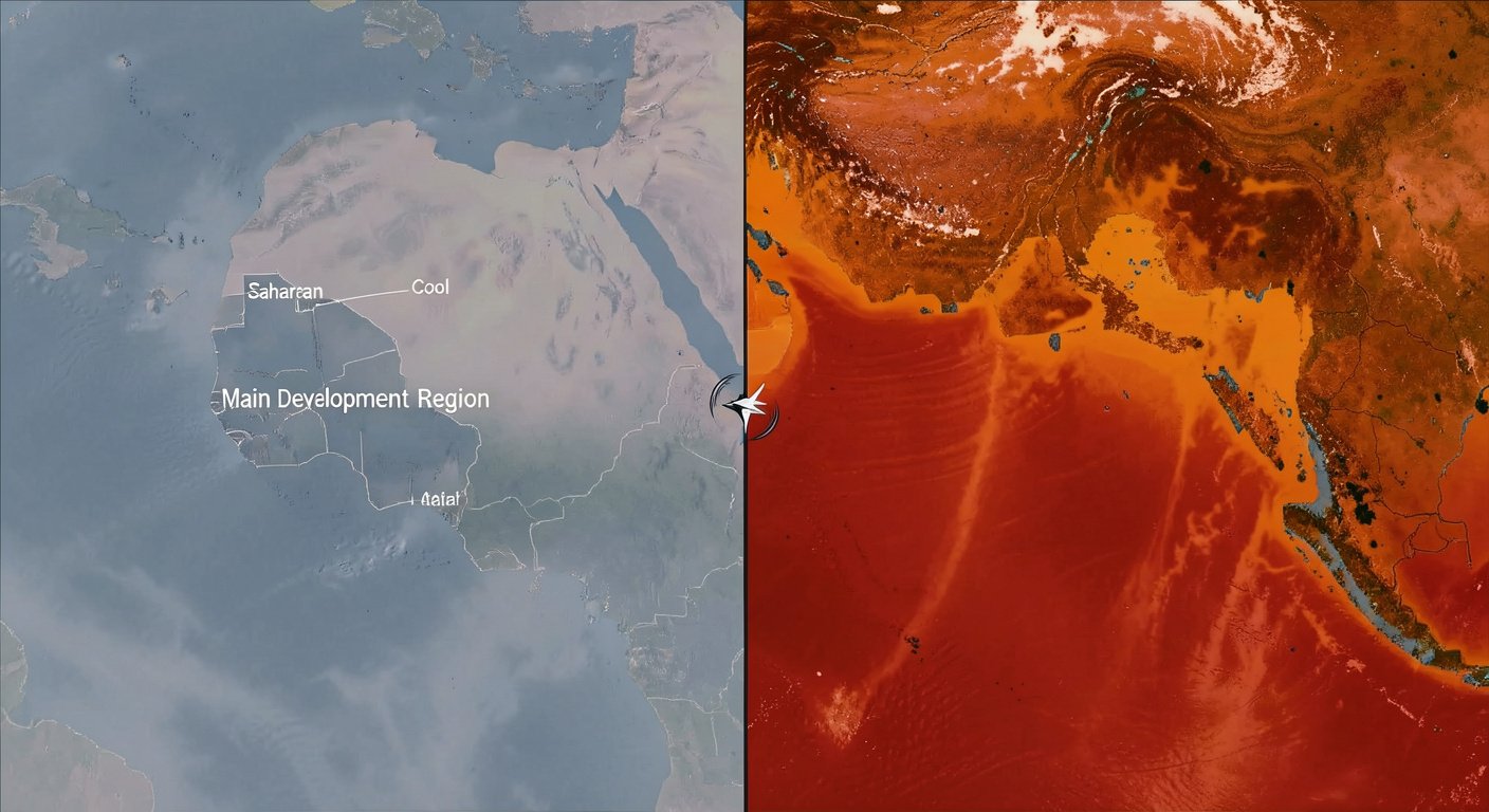
The eastern tropical Atlantic tells the opposite story. The Main Development Region, between Africa and the Caribbean, is cooler than normal. Enhanced trade winds and Saharan dust suppress the convection that seeds major hurricanes. [SOURCE: https://weather.substack.com/p/may-29-2026-friday-tropical-update]
The geographic split means fewer long-track Cape Verde hurricanes may form. But storms brewing closer to home, in the Caribbean or Gulf, will find explosive fuel waiting.
How It Affects People
Homes and Infrastructure
Water, not wind, remains the deadliest hurricane hazard. Inland freshwater flooding caused 57 percent of U.S. tropical cyclone deaths between 2013 and 2022. [SOURCE: https://www.ready.gov/hurricanes]
The National Hurricane Center’s new Flood Inundation Mapping tool delivers street-level flood projections for 60 percent of the U.S. population, expanding to nearly 100 percent by late September. [SOURCE: https://www.cpc.ncep.noaa.gov/products/outlooks/hurricane2026/May/hurricane.shtml]
The 2026 forecast cone extends tropical storm and hurricane watches to inland counties for the first time. It is a response to storms like 2024’s Hurricane Helene, which devastated communities in western North Carolina hundreds of miles from the Gulf. [SOURCE: https://www.cpc.ncep.noaa.gov/products/outlooks/hurricane2026/May/hurricane.shtml]
Insurance and the Economy
Since 1980, 190 Atlantic tropical cyclones have undergone rapid intensification, and 72 percent of billion-dollar U.S. storms did so before impact. [SOURCE: https://www.climatecentral.org/climate-matters/hurricane-season]
Damage scales nonlinearly with wind speed: the Gulf’s warming rate translates to roughly a 30 percent increase in damage potential per decade. [SOURCE: https://yaleclimateconnections.org/2026/05/something-startling-is-happening-in-the-gulf-of-mexico/]
Local Communities and the Risk of Complacency
The 2025 season produced three Category 5 hurricanes, the second-most in any season behind 2005, yet none made U.S. landfall. [SOURCE: https://www.bbc.com/weather/articles/cg5pg9prp3go] A below-normal forecast for 2026, arriving after a year of narrow escapes, invites a dangerous relaxation.
“It only takes one storm to make for a very bad season.”
Ken Graham, NOAA National Weather Service Director [SOURCE: https://www.noaa.gov/news-release/noaa-predicts-below-normal-2026-atlantic-hurricane-season]
In 1992, Hurricane Andrew struck south Florida during a below-normal season that produced only seven named storms. The season registered one of the lowest Accumulated Cyclone Energy values on record, yet Andrew caused $27.3 billion in damage. [SOURCE: https://www.noaa.gov/news-release/noaa-predicts-below-normal-2026-atlantic-hurricane-season]
Why It Matters Now
The Atlantic has been in a high-activity era since 1995, with 70 percent of seasons above normal and 32 percent hyperactive. [SOURCE: https://www.noaa.gov/news-release/noaa-predicts-below-normal-2026-atlantic-hurricane-season] A quiet 2026 would not mean the era has ended.
What has changed decisively is the ocean. All four major hurricanes of 2025 rapidly intensified, each reaching the extreme threshold of a 58-mph wind increase in 24 hours. [SOURCE: https://www.climatecentral.org/climate-matters/hurricane-season]
The Gulf of Mexico is warming 16 times faster than the long-term trend observed since 1850. [SOURCE: https://yaleclimateconnections.org/2026/05/something-startling-is-happening-in-the-gulf-of-mexico/] A 2026 study in Nature Communications suggests the 2015-16 super El Nino may have triggered a lasting shift in Gulf winter temperatures, and researchers are watching to see whether the current developing El Nino does the same. [SOURCE: https://wmo.int/news/media-centre/wmo-prepare-el-nino]
“The big story with this season will be the possibility of a very strong El Nino. This makes our forecast of an active year surprising.”
Kyle Davis, University of Arizona, lead author of the 2026 seasonal hurricane forecast [SOURCE: https://has.arizona.edu/news/forecast-2026-hurricane-activities-over-north-atlantic]
What You Should Know
NOAA’s preparedness framework begins with knowing your risk. Wind and water hazards extend far beyond the coastline. Inland residents accounted for the majority of tropical cyclone deaths over the past decade. [SOURCE: https://www.ready.gov/hurricanes]
Ready.gov recommends an emergency kit with three days of nonperishable food, one gallon of water per person per day, essential medications, and pet supplies. A “go bag” with documents and medications should be ready to grab. [SOURCE: https://www.ready.gov/hurricanes]
Wireless Emergency Alerts reach phones automatically with no sign-up required. Check on neighbors, especially seniors and people with disabilities.
The post-storm period carries lethal hazards: carbon monoxide from portable generators, downed power lines, and floodwater contamination. Six inches of moving water can knock an adult down. Twelve inches can sweep away a car.
Turn around, do not drown. [SOURCE: https://www.ready.gov/hurricanes]
Seasonal forecasts offer probabilities, not protection. The 2026 season will be defined not by how many storms form in the open Atlantic but by whether any of them find the Gulf’s warm loop on the way to land.
Review your evacuation plan, refresh your supplies, and treat every named storm as the one that could break the pattern. Visit NOAA’s Hurricane Preparedness Hub or Ready.gov.
Sources
- NOAA Predicts Below-Normal 2026 Atlantic Hurricane Season (May 21, 2026)
- NOAA CPC Atlantic Hurricane Outlook (May 2026)
- CPC ENSO Diagnostic Discussion (June 11, 2026)
- Yale Climate Connections: “Something Startling Is Happening in the Gulf of Mexico” (May 13, 2026)
- University of Arizona 2026 Hurricane Forecast (April 3, 2026)
- Colorado State University June 2026 Hurricane Forecast (June 10, 2026)
- Dr. Ryan Maue: May 29, 2026 Tropical Update (Weather Trader/Substack)
- BBC Weather: 2026 Atlantic Hurricane Season Forecast (May 21, 2026)
- Wikipedia: 2026 Atlantic Hurricane Season
- Wikipedia: 2025 Atlantic Hurricane Season
- Climate Central: 2026 Hurricane Season Resources (June 10, 2026)
- Ready.gov: Hurricanes
- NOAA Hurricane Preparedness Hub
- WMO: Prepare for El Nino (June 2, 2026)
- Team Rubicon: 2026 Hurricane Season Forecast (June 5, 2026)