Super El Niño 2026: What the Developing Event Means for Global Weather
It’s official: El Niño is here.
NOAA’s Climate Prediction Center confirmed on June 11 that El Niño conditions are now present in the tropical Pacific. And here’s the part that should get your attention — forecasters say there’s an 82% chance it sticks around through the winter of 2026-27, with growing odds it becomes a “super El Niño.”
That’s not a term scientists throw around lightly.
The UK Met Office says this event could rival the most impactful El Niños in recent history. CNN reports that chances are rising for “historically strong” conditions. The European Centre for Medium-Range Weather Forecasts (ECMWF) has been tracking its development since April.
So what does this actually mean for your weather? Let’s walk through it.
What El Niño actually is
Before we get into predictions, let’s make sure we’re on the same page about what El Niño is.
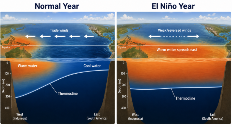
In normal years, trade winds blow from east to west across the equatorial Pacific, pushing warm surface water toward Asia. That allows cooler water to well up along the coast of South America.
During El Niño, those trade winds weaken. The warm water sloshes back eastward toward the Americas. That shifts where heat and moisture go up into the atmosphere — and that changes weather patterns across the entire planet.
It’s not a local event. It’s a planetary-scale engine that rearranges storm tracks, rainfall, and temperature patterns for months at a time.
For a refresher on the basics, our explainer on the difference between weather and climate helps put long-term patterns like El Niño in perspective.
Why 2026 could be different
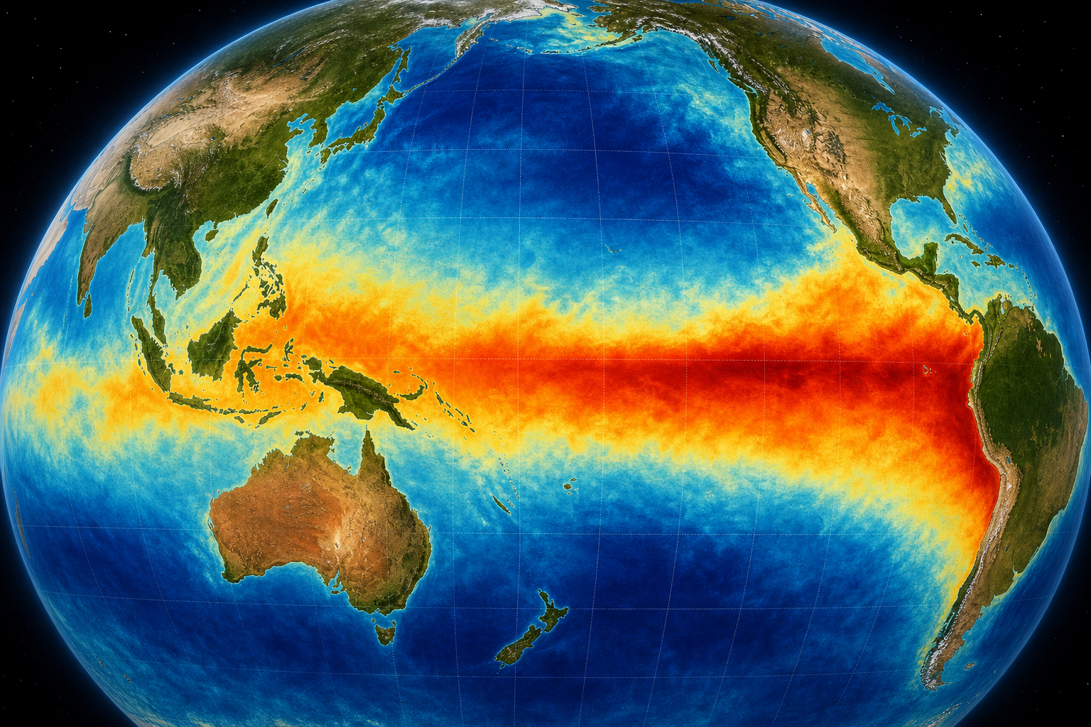
The current event started developing faster than many models predicted. Sea surface temperatures in the Niño 3.4 region — the key monitoring zone — have warmed rapidly since April.
What makes forecasters nervous is the amount of heat stored below the surface. Those subsurface temperatures are running well above normal, which means there’s a reservoir of warm water ready to feed the surface event for months.
Right now, the probability of a “strong” El Niño (peaking at 1.5°C or more above average) is well above 55%. Some models suggest it could reach “super” status — 2.0°C or higher — which has only happened a handful of times since records began.
The last comparable events were 1997-98 and 2015-16. Both broke global temperature records. Both triggered extreme weather worldwide.
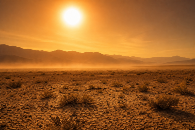
What this means for the US this summer
AccuWeather’s summer 2026 forecast describes a “volatile mix” of heat, severe storms, and flooding for the United States.
Here’s how El Niño typically affects the US during summer:
The South gets wetter. El Niño tends to shove the jet stream farther south, which means more storm systems across Texas, the Gulf states, and the Southeast. That’s good news for drought relief in some areas, but it also raises flood risk.
The North gets hotter. The Pacific Northwest and northern Plains tend to dry out and warm up during El Niño summers. That sets the stage for heat waves and wildfire risk.
Tornado activity shifts. El Niño changes wind shear patterns in ways that can either suppress or enhance tornado outbreaks depending on the season. We saw this play out with Illinois’ record-setting 140 tornadoes this year — a pattern that’s connected to the larger atmospheric setup.
The hurricane connection
Here’s one of the most talked-about effects: El Niño usually suppresses Atlantic hurricane activity.
Why? Because El Niño creates stronger upper-level winds over the Atlantic that tear apart developing tropical storms. Those winds — called wind shear — basically decapitate hurricanes before they can organize.
That doesn’t mean zero hurricanes. But it typically means fewer storms and weaker ones compared to a neutral or La Niña year.
Our Hurricanes 101 explainer covers exactly how wind shear and sea surface temperatures interact to determine hurricane strength — worth a read if you want the full picture.
But here’s the catch: this year’s Atlantic sea surface temperatures are also running well above normal. Warm water is hurricane fuel. So you’ve got two competing forces — El Niño’s wind shear trying to suppress storms, and record-warm oceans trying to supercharge them.
Which one wins? That’s the big question for the 2026 hurricane season.
Global impacts to watch
El Niño doesn’t stop at US borders. This is a worldwide event.
Record global warmth. May 2026 was the second hottest May ever recorded globally. El Niño on top of ongoing climate warming pretty much guarantees that 2026 will rank among the hottest years on record.
Europe’s heat dome. Europe just experienced a May heat dome that pushed temperatures 10-15°C above normal in some areas. Scientists say that may be linked to the emerging El Niño, which can influence the jet stream in ways that lock in heat over the continent.
Disrupted monsoons. El Niño tends to weaken the Indian monsoon, which has serious consequences for agriculture and water supplies in India and Southeast Asia. The Australian Bureau of Meteorology is already warning of drier conditions across eastern Australia.
Potential for drought in key regions. Indonesia, the Philippines, and parts of Africa often see below-average rainfall during strong El Niños. That can trigger food security issues that ripple through global markets.
What about winter?
The 82% probability that El Niño continues through the winter means we need to start thinking about December through February now.
For the US, typical El Niño winters bring:
- Warmer and drier across the northern states (Pacific Northwest to the Great Lakes)
- Cooler and wetter across the southern states (California to the Carolinas)
- More storms for California — potentially a wet winter that could relieve drought but also trigger flooding and mudslides
- Less snow for the Northeast and Midwest in general, though big snowstorms (Nor’easters) can still happen
If this event reaches “super El Niño” status, those patterns would be amplified.
The bottom line
El Niño 2026 is developing fast and looks like it could be a big one. NOAA, the Met Office, and ECMWF are all watching closely.
What we know:
- El Niño is here and likely to strengthen
- There’s an 82% chance it lasts through the winter
- Summer will bring a volatile mix of heat, storms, and flood risks
- Atlantic hurricane activity will likely be suppressed — but not guaranteed to be quiet
- Global temperatures are poised to spike
What we don’t know:
- Exactly how strong it will get
- How it will interact with record-warm oceans
- Whether the typical El Niño patterns will hold, or if climate change is rewriting the rules
That last point is key. As our weather vs climate article explains, El Niño is a natural cycle — but it’s now operating on top of a fundamentally altered climate system. The combination could produce outcomes we haven’t seen before.
Stay tuned. This is going to be a fascinating — and potentially challenging — year for global weather.
Sources: NOAA/CPC, Met Office, ECMWF, AccuWeather, CNN, UK Met Office