2026 Atlantic Hurricane Season: Why Below-Normal Does Not Mean No Risk
By NatureWeatherHub Team
Reading Time: 6 Minutes
A hurricane can change a life in a single afternoon. The forecast may say quiet, but the ocean does not always follow instructions.
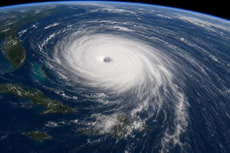
On May 21, NOAA released its outlook for the 2026 Atlantic hurricane season, and the headline was not what coastal residents expected after two punishing years. There is a 55 percent chance of a below-normal season, with 8 to 14 named storms compared with a historical average of 14. Hurricanes may number 3 to 6, down from the average of 7. Major hurricanes of Category 3 or higher could be as few as 1 instead of the usual 3. The odds of an above-normal season stand at just 10 percent.
It sounded like a reprieve. But inside the same press release, National Weather Service Director Ken Graham offered a careful warning: “Although El Niño’s impact in the Atlantic Basin can often suppress hurricane development, there is still uncertainty in how each season will unfold. That is why it’s essential to review your hurricane preparedness plan now. It only takes one storm to make for a very bad season.”
This is the central tension of the 2026 hurricane season. The probabilities are lower. The risk has not disappeared.
What the Forecast Actually Says
The probability distribution leans heavily toward below-normal activity, with a near-normal probability of 35 percent and an above-normal chance of just 10 percent. [SOURCE: NOAA Press Release May 21, 2026]
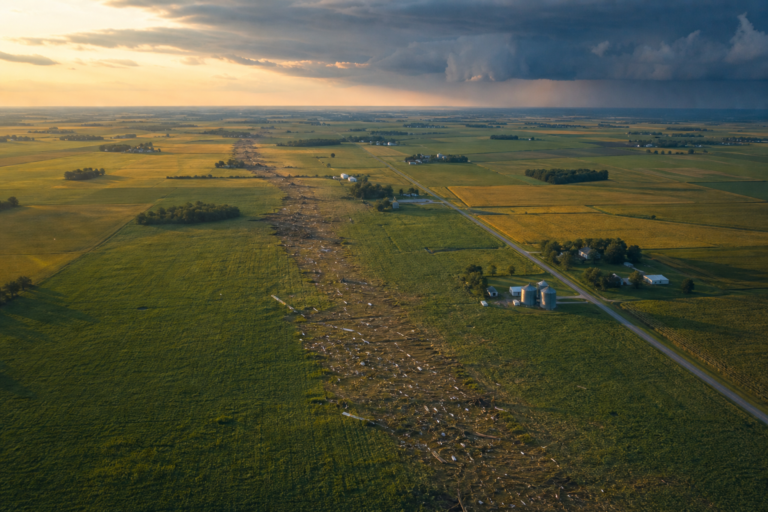
The ranges tell a more complicated story. The upper end, 14 named storms and 6 hurricanes, still represents a season that can produce serious landfalls. A single Category 4 or 5 hurricane can cause tens of billions in damage regardless of how many other storms formed. Hurricane Michael arrived during a below-normal season in 2018. It still devastated the Florida Panhandle as a Category 5.
As of June 18, the National Hurricane Center had not recorded a single named storm. That is not unusual. The season runs from June 1 through November 30, with peak activity concentrated between mid-September and October. [SOURCE: NHC]
Colorado State University has also reduced its seasonal forecast for 2026, citing warm neutral ENSO conditions.
Why It Happens
Two powerful forces are pulling the 2026 hurricane season in opposite directions.
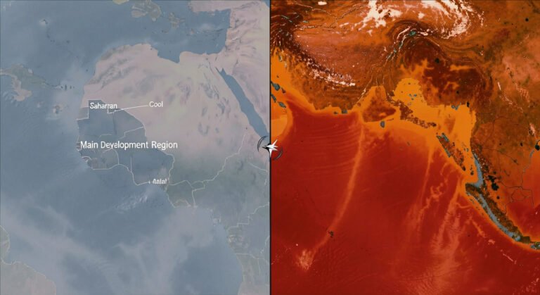
The first is El Niño. This natural climate pattern, now developing in the equatorial Pacific, tends to suppress Atlantic hurricane activity. El Niño increases vertical wind shear across the tropical Atlantic. Wind shear is the change in wind speed and direction with height. Hurricanes need a tall, calm column of air to build their thunderstorms. Strong shear tears that structure apart before it can organize. [SOURCE: NOAA Press Release May 21, 2026]
The second force is the Atlantic Ocean itself. Sea surface temperatures remain warmer than normal. Warm water is hurricane fuel. It provides the heat and moisture that power a storm’s engine. When ocean temperatures run above average, the potential for rapid intensification, in which a storm strengthens by 35 mph or more in 24 hours, increases. Trade winds that normally cool the ocean surface and keep storm development in check have been weaker than usual. [SOURCE: NOAA Press Release May 21, 2026]
These two forces are not cooperating. El Niño is pressing down on storm formation. The warm Atlantic is pushing up from below. The ingredients for hurricanes are present. Whether they combine depends on which force wins in any given week.
Social Media Highlight
“It only takes one storm to make for a very bad season.”
How It Affects People
For the millions of people who live along the Atlantic and Gulf coasts, a below-normal forecast carries a specific kind of risk: complacency.
Safety is the most immediate concern. Evacuation routes, emergency kits, and family communication plans work only if prepared before a storm appears on the radar. The window between a tropical disturbance forming and a hurricane warning can be as short as 48 hours. In a below-normal year, the temptation is to skip the preparation. Emergency managers across the Southeast have spent weeks reminding residents the probabilities have not dropped to zero.
Insurance reflects the same tension. After two above-normal seasons, property insurance premiums in hurricane-prone states have climbed sharply. Some private insurers have pulled back from coastal markets entirely. A quiet 2026 could help stabilize those markets. A single landfalling major hurricane, even in a below-normal year, could accelerate the withdrawal.
The economic consequences extend beyond insurance. Coastal communities from Texas to the Carolinas depend on summer tourism. A hurricane threat, even one that does not materialize, can empty beach hotels for days or weeks. Travelers planning late-summer visits to hurricane-prone destinations should understand that a below-normal forecast does not eliminate the need for flexible bookings.
There is a mental burden as well. Even the threat of a hurricane can produce measurable anxiety. The sound of wind, the sight of a forecast cone aimed at one’s town, the uncertainty of whether to leave or stay. These stresses do not vanish in a quiet year.
Why It Matters Now
NOAA announced several upgrades for 2026. The Tropical Cyclone Forecast Cone Graphic now includes inland tropical storm and hurricane watches and warnings for the continental United States. Previously, the cone focused on the coast. The new version shows hazards extending far inland, where flooding from rainfall often causes more damage than the wind at landfall. [SOURCE: NOAA Press Release May 21, 2026]
Flood Inundation Mapping, which provides high-resolution visualization of storm surge and inland flooding, now covers roughly 60 percent of the U.S. population. NOAA plans to expand that to nearly 100 percent by late September. [SOURCE: NOAA Press Release May 21, 2026]
The Hurricane Analysis and Forecast System now integrates data from small drones that fly into the lower levels of hurricanes. NOAA reports this has improved intensity forecasts by roughly 10 percent. Machine learning applied to Doppler radar data from hurricane hunters has increased high-quality meteorological data by 25 percent. [SOURCE: NOAA Press Release May 21, 2026]
Climate change adds urgency. Hurricanes are becoming wetter and stronger on average, even if total numbers do not increase. A warmer atmosphere holds more moisture, which falls as heavier rain. Warmer oceans provide more energy for intensification. Storm surge, already the deadliest hurricane hazard, is rising on a higher baseline sea level. A storm in a below-normal season can still carry the fingerprints of a warming planet.
What We Can Learn
The 2026 hurricane season tests how the public processes probabilistic information. NOAA is not saying hurricanes will not happen. It is saying the odds are lower. The distinction matters.
Preparation should not track the seasonal forecast. It should track the reality that every coastal resident from Texas to Maine lives in a zone where a hurricane is possible. An evacuation plan, a supply kit with at least three days of food and water, a way to receive warnings, and an understanding of local flood zones. These are not optional in any year.
The new forecast products deserve attention. The inland warning cone, the flood maps, and the improved intensity forecasts give people more time and better information. Using them requires knowing they exist.
A below-normal hurricane season is not a season without hurricanes. It is a season with a narrower margin for bad luck. When that margin runs out, the difference between a close call and a disaster comes down to whether people took the forecast seriously, not just its headline number, but its quiet warning.
Final Social Highlight
“A below-normal hurricane season is not a season without hurricanes. It is a season with a narrower margin for bad luck.”