El Niño Complete Guide: What It Is, How It Forms, and How It Changes Weather Worldwide
By NatureWeatherHub Team
Reading Time: 10 Minutes
A fisherman on the coast of Peru notices the water is warmer than usual. The anchovies have vanished. Six months later, a farmer in Australia watches his wheat wither under a cloudless sky, while a family in California sandbags their home against storms that should not arrive until winter. All of these people are experiencing the same invisible force: El Niño.

El Niño is not a storm. It is not a heat wave. It is a slow, planetary-scale reorganization of the Pacific Ocean and the atmosphere above it, one that reaches into your grocery bill, your electricity consumption, your travel plans, and your community’s disaster preparedness. In 2026, with the World Meteorological Organization confirming an 80 percent likelihood of El Niño conditions developing between June and August, understanding this phenomenon has never been more urgent.
This guide explains what El Niño is, how it forms, its worldwide impacts, and what you can do to prepare.
What Is El Niño?
El Niño is the warm phase of the El Niño-Southern Oscillation, or ENSO, a natural climate pattern that shifts back and forth across the tropical Pacific Ocean. The name, Spanish for “little boy,” was given by Peruvian fishermen centuries ago, who noticed that unusually warm coastal waters appeared every few years around Christmas, disrupting the anchovy harvest that sustained their villages.
In neutral conditions, strong easterly trade winds push warm surface water from the coast of South America toward Asia, piling it up in the western Pacific. Cold, nutrient-rich water rises from the deep ocean to replace it along the South American coast in a process called upwelling. This cold water feeds one of the world’s richest marine ecosystems and keeps coastal temperatures moderate.
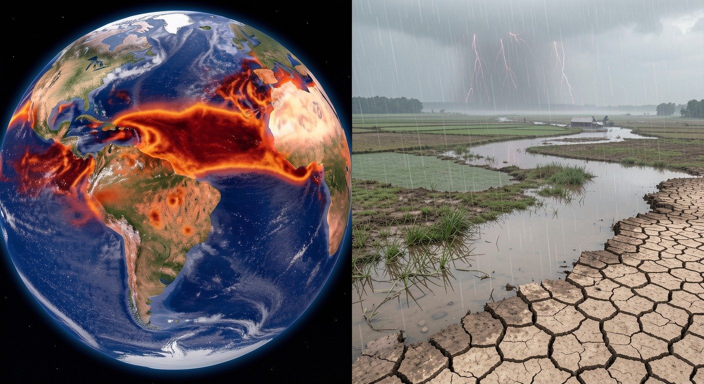
During an El Niño event, those trade winds weaken or even reverse direction. The pool of warm water that had been held in the western Pacific sloshes eastward toward the Americas, like water in a bathtub when someone tips the end. Upwelling shuts down. The eastern tropical Pacific warms, sometimes by 2 to 3 degrees Celsius or more above normal, and the entire atmospheric engine that drives weather across the tropics shifts location.
According to NOAA, an El Niño is officially declared when sea surface temperatures in the Niño‑3.4 region, a monitoring zone in the central equatorial Pacific, exceed the long-term average by at least 0.5 degrees Celsius for five consecutive overlapping three-month periods, and the atmosphere shows consistent changes in cloudiness, pressure, and wind patterns. [SOURCE: https://www.climate.gov/enso]
The opposite phase, La Niña, occurs when trade winds strengthen, pushing even more warm water toward Asia and intensifying the upwelling of cold water off the Americas. Together, El Niño and La Niña form a natural pendulum that swings every two to seven years, each event typically lasting nine to twelve months.
Why It Happens: The Science Behind El Niño
Simple Explanation
Think of the tropical Pacific Ocean as a giant pan of water sitting on a stove. In normal conditions, the flame is under the western side near Indonesia, where warm water accumulates and drives heavy tropical rainfall. The trade winds act like a fan blowing from east to west, holding the warm water in place.
During El Niño, the fan weakens. The warm water sloshes back toward the middle and east, shifting the rainfall with it. Places that are normally wet become dry, and places that are normally dry can suddenly receive torrential rain.
The Professional Term: The Walker Circulation
Scientists call the atmospheric engine that El Niño disrupts the Walker Circulation, named after British mathematician Sir Gilbert Walker, who discovered it in the 1920s while trying to predict the Indian monsoon. In neutral conditions, the Walker Circulation operates as a giant loop: warm, moist air rises over the western Pacific, travels eastward high in the atmosphere, descends as cool, dry air over the eastern Pacific, and returns westward along the surface as the trade winds. This loop is the main driver of tropical rainfall patterns.
When El Niño begins, the warm pool shifts east and the rising branch of the Walker Circulation moves with it, weakening or splitting the entire loop. According to NASA, “El Niño is one of the most important weather-producing phenomena on Earth, a ‘master weather-maker.’” The shift in the Walker Circulation alters rainfall, storm tracks, and jet stream positions across the entire planet through atmospheric connections scientists call teleconnections. [SOURCE: https://science.nasa.gov/earth/explore/el-nino/]
A Real-World Example
During the 2015‑2016 El Niño, one of the strongest ever recorded, ocean temperatures in the central Pacific rose more than 2.5 degrees Celsius above average. The resulting shift in the Walker Circulation triggered drought across Indonesia that fueled massive wildfires, flooding in Peru and Ecuador, a record-breaking hurricane season in the eastern Pacific, and the warmest global temperatures ever recorded at the time. The event left an estimated 60 million people in need of food aid. [SOURCE: https://science.nasa.gov/earth/explore/el-nino/]
Social Media Highlight
“El Niño is not a storm. It is a message from the Pacific Ocean, delivered through drought, flood, and fire, that our planet is deeply connected in ways we are only beginning to understand.”
How It Affects People
El Niño touches nearly every aspect of human life. Its reach extends far beyond weather maps and into the daily reality of communities across the globe. Here are the most significant ways it affects people.
Food and Agriculture
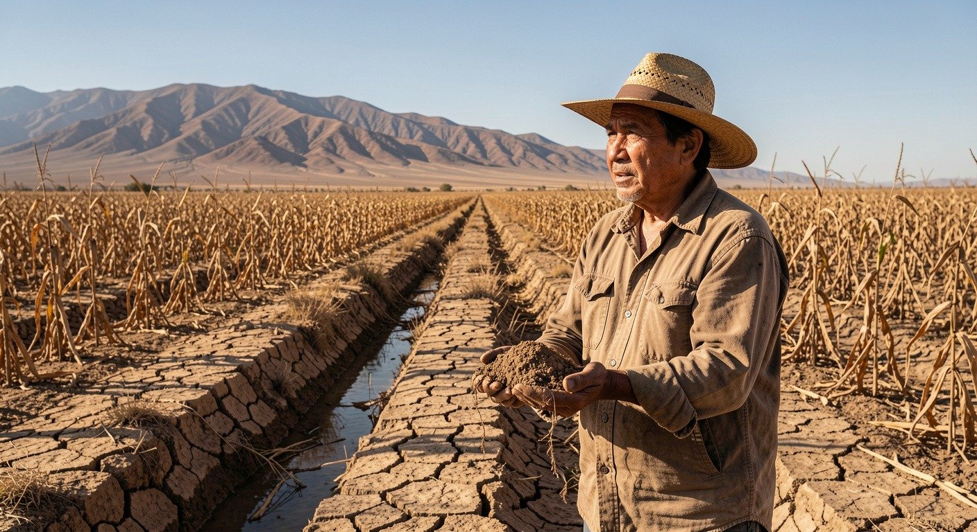
Agriculture is the frontline of El Niño impacts. According to the World Resources Institute, El Niño shifts food production risk globally: some regions benefit from increased rainfall, but many more face drought, heat stress, and crop failure. Rainfed, low-income, and import-dependent regions are most vulnerable. During past El Niño events, Southern Africa has consistently shown reduced cereal production, while Southeast Asian rice farmers have faced water shortages that threaten a staple crop consumed by billions. [SOURCE: https://www.wri.org/insights/super-el-nino-impacts-explained]
The 2026 El Niño arrives at a fragile moment. Fuel and fertilizer shortages linked to geopolitical conflict have already raised input costs for farmers worldwide. According to the World Resources Institute, even after El Niño fades, reduced fertilizer use, poor harvests, livestock losses, and depleted savings can affect the following planting season, creating a cascade that lasts well beyond the event itself.
Health
The World Health Organization warns that El Niño should be treated as much of a public health threat as a climate hazard. Extreme heat can push temperatures beyond safe thresholds for outdoor workers, the elderly, children, and people with chronic illnesses. Heat stress degrades sleep, productivity, and learning. Wildfire smoke from El Niño-driven fires exposes millions to hazardous air. Drought can reduce access to clean water, increasing the spread of waterborne disease. And nutrition shocks, caused by crop failures and rising food prices, hit the most vulnerable populations hardest. [SOURCE: https://www.weforum.org/stories/2026/06/the-coming-el-nino-is-more-than-a-climate-event-it-is-a-systemic-shock/]
Water and Infrastructure
El Niño intensifies both extremes of the water cycle. According to the World Resources Institute, drought-prone regions including the Caribbean, Central America, central and southern Africa, Indonesia, and Australia typically receive less rainfall, while flood-prone regions including the southern United States, Peru, Ecuador, and parts of East Africa face elevated flood risk. These effects cascade into drinking water supplies, hydroelectric power generation, and inland transport networks. Low river levels disrupt barge traffic on major waterways like the Mississippi, while flooded roads and damaged ports interrupt supply chains. [SOURCE: https://www.wri.org/insights/super-el-nino-impacts-explained]
Economies and Communities
The economic cost of El Niño is staggering and long-lasting. A landmark 2023 study published in the journal Science found that El Niño events persistently reduce country-level economic growth, with the 1982‑1983 event causing 4.1 trillion dollars in global income losses and the 1997‑1998 event causing 5.7 trillion dollars. The researchers projected that under current climate policies, increased ENSO variability could cause 84 trillion dollars in economic losses over the 21st century. [SOURCE: https://www.science.org/doi/10.1126/science.adf2983]
These numbers translate into real human consequences: families unable to afford food after crop failures, communities displaced by floods, governments forced to divert funds from education and healthcare to disaster response, and migration pressures that reshape entire regions.
Wildlife and Ecosystems
El Niño’s oceanic warming devastates marine life. When upwelling shuts down, phytoplankton, the microscopic plants at the base of the marine food web, collapse. Fish stocks vanish. Sea birds, seals, and sea lions starve. According to NASA, the 1982‑1983 event killed approximately 25 percent of the fur seal and sea lion population off Peru. Coral reefs, already stressed by rising ocean temperatures, suffer widespread bleaching during El Niño events, with the 2023‑2024 event causing significant damage to the Great Barrier Reef. [SOURCE: https://science.nasa.gov/earth/explore/el-nino/]
On land, drought-stressed forests become tinderboxes. The World Resources Institute reports that during the 2015‑2016 and 2023‑2024 El Niño events, fires burned more than 2.3 million hectares of forest in Brazil each time, more than four times the annual average. [SOURCE: https://www.wri.org/insights/super-el-nino-impacts-explained]
Why It Matters Now: The 2026 Outlook
The 2026 El Niño is unfolding in a world fundamentally different from the one that experienced the last major event in 2023‑2024.
The World Meteorological Organization’s June 2026 update gives an 80 percent likelihood of El Niño conditions developing during June through August, with a roughly 90 percent probability it continues until at least November 2026. Most forecast models suggest a moderate to strong event. NOAA estimates a greater than 80 percent probability it will start between May and July and a 96 percent probability it will persist into early 2027. [SOURCE: https://wmo.int/news/media-centre/wmo-prepare-el-nino] [SOURCE: https://www.weforum.org/stories/2026/06/the-coming-el-nino-is-more-than-a-climate-event-it-is-a-systemic-shock/]
Three factors make this El Niño especially concerning.
First, it arrives on top of the warmest period in recorded history. The past eleven years are the warmest on record, meaning even a moderate El Niño can produce temperature anomalies and extreme weather that would previously have required a much stronger event. According to the European Centre for Medium-Range Weather Forecasts, the warming baseline means the Pacific is “in a precarious equilibrium.”
Second, ongoing geopolitical instability, particularly the U.S.-Iran conflict, has driven up fuel and fertilizer costs globally. Farmers enter this El Niño with thinner margins, less access to inputs, and reduced capacity to absorb a bad season. The World Economic Forum warns that the combination of climate shock and supply chain strain creates a systemic risk, threatening “yields just as a prolonged crisis around the Strait of Hormuz raises farm costs and tightens food supplies.”
Third, subsurface observations from the TAO/TRITON buoy array across the Pacific show a warm water mass, a Kelvin wave, propagating eastward. These waves are “the silent messengers of El Niño,” according to Infoplaza’s meteorological team, transporting warm water from the western Pacific toward South America and capable of pushing surface temperatures above the El Niño threshold in the coming months. [SOURCE: https://www.infoplaza.com/en/blog/is-the-pacific-ocean-heading-towards-a-new-el-niño-in-2026]
UN Secretary-General António Guterres summarized the urgency in stark terms: “The science is clear: El Niño is arriving on our doorstep in the coming months with 90 percent certainty. The world must treat it as the urgent climate warning it is.” [SOURCE: https://wmo.int/news/media-centre/wmo-prepare-el-nino]
What We Can Learn: Preparedness and Perspective
El Niño is a natural phenomenon that has shaped human history for centuries. The strongest El Niño ever recorded, in 1877‑1878, triggered simultaneous droughts across Asia, Africa, and Latin America and contributed to the Global Famine of 1876‑1878, which killed an estimated 50 million people. We cannot stop El Niño from occurring, but we can stop being surprised by it.
Modern forecasting, satellite observations, and international coordination give us advantages previous generations never had. The WMO’s El Niño/La Niña Update combines models from the world’s leading climate centers, providing governments, humanitarian agencies, and climate-sensitive sectors with months of advance warning. That warning is actionable.
The World Resources Institute points to anticipatory action programs that work: distributing drought-resilient seeds before planting seasons, repairing irrigation systems ahead of dry spells, building flood protection in communities forecast to receive heavy rain, and providing cash transfers so families can evacuate before disaster strikes. These interventions cost far less than emergency response after the fact and save lives.
On a personal level, understanding El Niño helps you make better decisions. If you live in a region likely to experience drought, now is the time to check water storage, review fire evacuation plans, and consider drought-tolerant landscaping. If you live in a flood-prone region, know your evacuation routes, keep emergency supplies, and ensure your insurance is current. If you are a gardener, farmer, or simply someone who cares about food prices, pay attention to seasonal outlooks and support policies that build food system resilience.
The broader lesson is about interconnection. A change in ocean temperature thousands of miles away reaches into your life through the price of rice, the intensity of the next storm season, and the air quality on a summer afternoon. As NASA puts it: “If you want to understand how interconnected our planet is, study El Niño.”

Final Call to Action
“El Niño does not have to be a catastrophe. With advance warning, early preparation, and global cooperation, we can protect lives and livelihoods. The Pacific Ocean is speaking. The only question is whether we are listening.”