
Captain Edward Connors had 30 seconds. His Lockheed L-1011 was on final approach to Dallas-Fort Worth, descending through a summer thunderstorm on August 2, 1985. The airspeed indicator flickered. A sudden headwind pushed the nose up, then a tailwind slammed it down. The wings lost lift. Delta Flight 191 struck the ground a mile from the runway, killing 137 people. The culprit was not a tornado. It was a microburst.
Understanding what is a microburst begins with that moment. The name sounds small, almost harmless, a “micro” burst, what damage could it do? The answer: wind speeds of 100 miles per hour or more, capable of leveling a barn, snapping rows of mature trees, and pushing a commercial airliner out of the sky, all within a circle just 2.5 miles wide.
What Is a Microburst? The Simple Answer
A microburst is a localized column of rapidly sinking air inside a thunderstorm. It hits the ground and explodes outward in every direction, producing straight-line winds of 60 to over 100 miles per hour. The entire event lasts 5 to 15 minutes. The affected area is small: 2.5 miles or less in diameter.
In simple terms: a thunderstorm builds up a massive load of rain and ice high in the sky. The updraft that was holding it up weakens, and all that cold, heavy air comes crashing down at highway speeds. When it hits the ground, it spreads outward like water from a hose hitting pavement.
The professional term, microburst, was coined in the late 1970s by Dr. Tetsuya “Ted” Fujita, the same meteorologist who developed the tornado intensity scale. According to the National Weather Service, Fujita identified microbursts while investigating aircraft accidents that could not be explained by existing weather models. The phenomenon had killed hundreds of people before anyone had a name for it.
How a Microburst Forms: The Three Stages

The microburst formation process follows three distinct stages identified by Fujita, each unfolding in minutes.
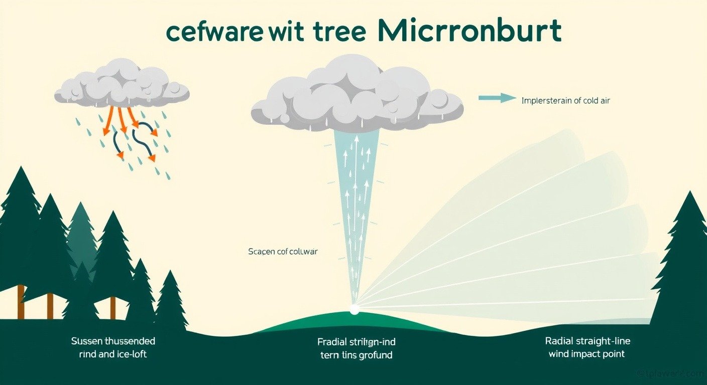
Contact stage. A thunderstorm’s updraft holds millions of tons of water and ice suspended in the cloud. When the updraft weakens, the load becomes too heavy. Cold, dense air plunges toward the ground, accelerating as it falls. This is the downburst: a column of air heading straight down at speeds that can exceed 100 miles per hour, as documented by the NOAA National Severe Storms Laboratory.
Outburst stage. The descending column strikes the ground and cannot go further. It spreads outward in all directions, forming a ring of violent straight-line winds. Trees snap outward from the center. Roofs peel back. The downburst explained this way is deceptively simple: a falling column of air that hits the ground like a hammer. The damage pattern is radial: everything points away from a single impact point.
Cushion stage. The outflow slows as it spreads, friction with the ground and surrounding air bleeding away its energy. Within 5 to 15 minutes, the microburst is gone. The thunderstorm that produced it may still be overhead, and it can produce another one.
The key to understanding microburst formation is evaporation. As rain falls through dry air beneath the cloud, it evaporates, and evaporation cools. Colder air is heavier, so it accelerates downward. This is why the Farmers’ Almanac notes that the most violent microbursts often occur in storms where much of the rain never reaches the ground at all. The parent thunderstorm, as explained in our guide to how thunderstorms form, provides the massive updraft that builds the water load aloft in the first place.
Wet vs Dry: The Two Faces of a Microburst
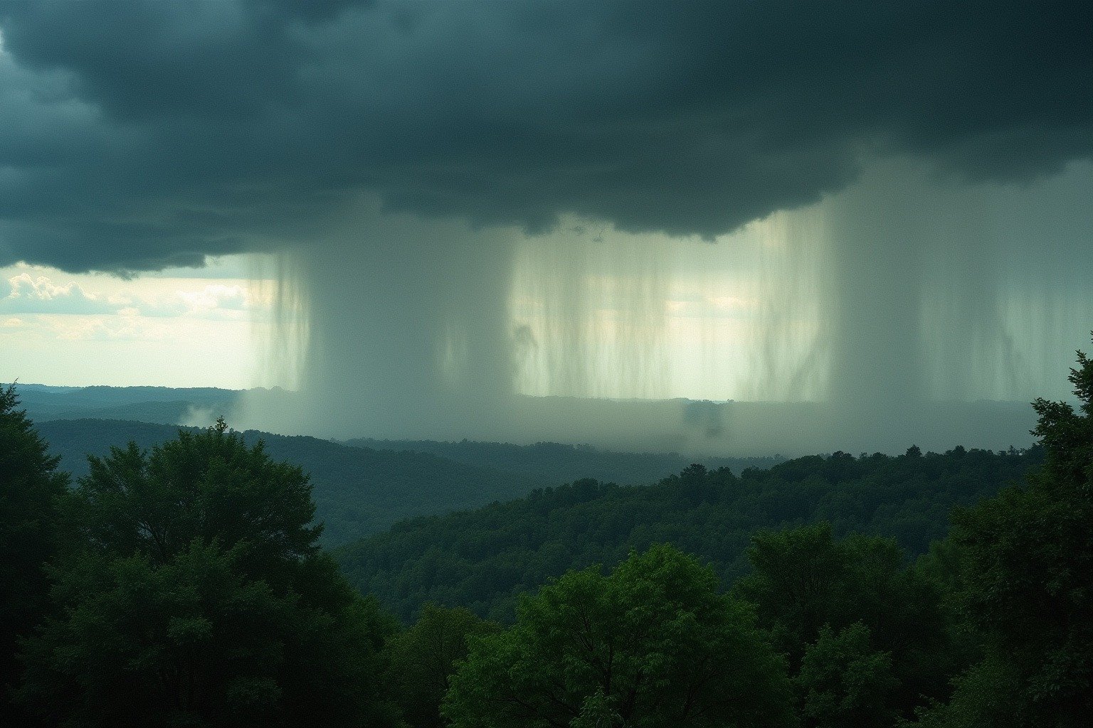
Not all microbursts look the same. There are two types, and one of them is almost invisible.
Wet microbursts come with heavy rain. You can see the rain shaft descending. These are most common in the humid Southeast, the Gulf Coast, and Florida, where summer thunderstorms carry enormous moisture loads. The rain itself is a visual warning, though it arrives with the wind, not before it.
Dry microbursts are far more dangerous. The rain evaporates completely before reaching the ground, leaving only a faint wisp called virga beneath the cloud. You see nothing unusual. And then the wind hits.
Dry microbursts dominate the Southwest, the Great Basin, and the Front Range of the Rockies, where surface air is hot and dry. A thunderstorm builds over the mountains, the rain falls into desert air, evaporates, super-cools, and slams into the ground. The sky may look clear where you are standing.
Both types produce the same wind speeds. Both can level structures. The critical difference: with a wet microburst, you have a visual cue. With a dry microburst, your first warning is the wind itself.
Microburst vs Tornado: How to Tell the Difference
After a storm, the damage looks similar: roofs gone, trees down, barns flattened. Homeowners and even local news often report “a tornado hit us.” But the National Weather Service can tell them apart by a single detail.
The damage pattern. A microburst produces radial damage: trees fall outward in straight lines from a central point, like spokes on a wheel. A tornado produces swirling damage: trees fall in different directions, sometimes wrapped around each other, debris scattered in chaotic spirals. The microburst damage assessment method used by NWS survey teams has revealed something surprising: many storms initially reported as tornadoes are, on closer inspection, microbursts. The radial tree-fall pattern is the giveaway.
This distinction matters beyond meteorology. Insurance policies sometimes treat tornado damage differently from straight-line wind damage. The microburst wind speed can match an EF1 tornado, 86 to 110 miles per hour, but the claim is classified differently. Knowing the difference changes what your policy covers.
The size also differs. A microburst is under 2.5 miles wide. Anything larger is a macroburst, which can stretch over 2.5 miles and last longer. A downburst is the umbrella term for both. A derecho is an entirely different phenomenon: a long-lived, widespread straight-line windstorm that travels hundreds of miles, not the localized collapse of a single thunderstorm. Understanding what is a microburst also means knowing what it is not: it has no funnel cloud and no rotating updraft, which is why how tornadoes form is a completely different story.
The Delta 191 Story: When a Microburst Changed Aviation Forever
The crash of Delta Flight 191 on August 2, 1985, killed 137 people and transformed aviation safety worldwide. The microburst aviation danger had been invisible to pilots and controllers alike because the technology to detect it simply did not exist. The National Transportation Safety Board investigation found that the aircraft encountered a microburst during its final approach. In the space of seconds, the wind shifted from a 26-knot headwind to a 46-knot tailwind. The airspeed collapsed. The pilots had no warning and no procedure for what they experienced.
The response was unprecedented. The Federal Aviation Administration mandated wind shear detection equipment on every commercial aircraft in U.S. airspace. Airports installed Terminal Doppler Weather Radar, or TDWR, designed specifically to detect microbursts and low-level wind shear. Pilot training incorporated microburst recognition and escape maneuvers. Air traffic controllers received new protocols: when TDWR detects a microburst, the runway closes.
The results are measurable. The last fatal commercial microburst crash in the United States was USAir Flight 1016 in Charlotte in July 1994, which killed 37 people. Since then, despite thousands of microbursts occurring near U.S. airports every summer, no commercial flight has been lost to one. According to NOAA’s NSSL, phased array radar can now capture 29 clear images of a developing microburst in the time conventional radar captures just 6. The warning window, once zero seconds, is now 1 to 3 minutes. That is enough.
Where and When Microbursts Strike
Microburst geography follows the moisture map of the United States. The Southeast and Gulf Coast see wet microbursts from June through September, peaking in July and August when afternoon thunderstorms are most frequent. Florida is the single most prolific state for wet microbursts.
The Southwest, Great Basin, and Rocky Mountain Front Range see dry microbursts during the same summer months. Phoenix, Denver, and Albuquerque all experience them regularly. The Great Plains are a mixed zone: both types occur depending on the storm’s moisture profile.
The time of day matters. Microbursts peak between 3 p.m. and 7 p.m., when the sun has done its work warming the surface and destabilizing the atmosphere. A dry microburst can form in a thunderstorm that looks unremarkable on radar, which is why forecasters rely on Doppler velocity data rather than reflectivity alone to spot the telltale divergence couplet that signals sinking air.
Safety: What to Do When a Microburst Warning Is Issued
The safety protocol for a microburst is the same protocol for any severe thunderstorm warning. Get inside. Stay away from windows. Move to an interior room on the lowest floor. A microburst wind speed of 100 miles per hour is EF1 tornado territory. Your house can handle it if you are not in the room with the windows.
If you are driving, pull over and get inside a building. Do not shelter in your car. Do not park under trees. A mature oak that has stood for a century can become a projectile in a microburst.
For pilots: the training exists. The onboard wind shear alert system, mandated on all commercial aircraft since Delta 191, will tell you what is happening. The escape maneuver, maximum thrust, nose up, gear up, is drilled in simulators. Trust the training. Trust the system that 137 lives bought.
For the rest of us: treat severe thunderstorm warnings with the same urgency as tornado warnings. A microburst has no funnel cloud to photograph. It has no dramatic sky signature. It has only wind, arriving fast, and the knowledge that modern detection gives you minutes, not seconds, to act. The same downburst physics power other dramatic phenomena: haboobs, those walls of desert dust, are born from the same collapsing thunderstorm outflow.